


Thermal Imaging Drones for Inspections and Search & Rescue Operations
 Skydio
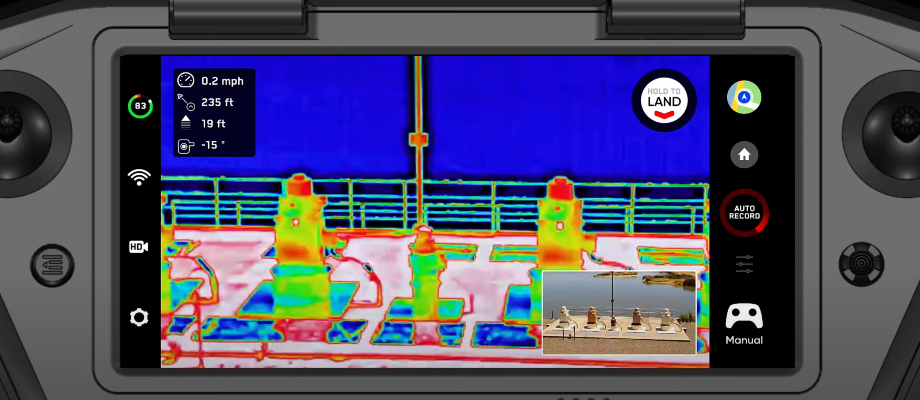
Persistent advances in thermal technology have led to significant growth in the thermal imaging market since its first commercial use in the 1960s for high voltage power line inspections. In a 2020 thermal imaging market research report published by Fortune Business Insights, the global thermal imaging market size was estimated to be $2.27 billion in 2019 & is projected to reach $4.10 billion by 2027, exhibiting a compound annual growth rate of 7.7% during the forecast period. With broad, growing applications across inspections, law enforcement, and SAR (search and rescue) operations, it was only a matter of time before Skydio released a drone with thermal data collection capabilities.
Skydio X2 thermal settings enhancements
In May of 2021, Skydio launched the X2 series. A set of drones that utilize the same groundbreaking autonomous flight technology as its predecessors but implement it on a ruggedized vehicle with multiple variants, including a single-sensor drone with a color payload and a dual-sensor drone with thermal & color payloads. Since then, users have been able to capture thermal data using the FLIR Boson 320p thermal sensor equipped to the X2 color/thermal drone.
We’re constantly striving to improve, introducing features and enhancements that serve our customers. In October of last year, we released FLIR thermal palette options, and with our latest software update for the Skydio X2E, we’ve added new thermal settings & enhancements to enable users to get more out of their infrared data.
Enhancements to thermal settings
Automatic Gain Control (AGC) tuning
Thermal cameras make it intuitive to quickly identify heat and temperature differences to find people during safety/reconnaissance missions or faulty equipment that isn’t operating within safe operating temperatures during inspections. Previously, with thermal imaging on the X2 drone, you’ve been able to view thermal imagery on the following color palette options: white hot, black hot, rainbow, and ironbow. Now there are more settings available to meet your operational requirements.
With AGC Tuning, your thermal image's gain, or signal noise, will automatically optimize for the contrast you have selected. Switching between thermal contrast levels changes the appearance of a scene and highlights key areas of a thermal image without impacting temperature data. With more options, operators can toggle between views depending on different environments.
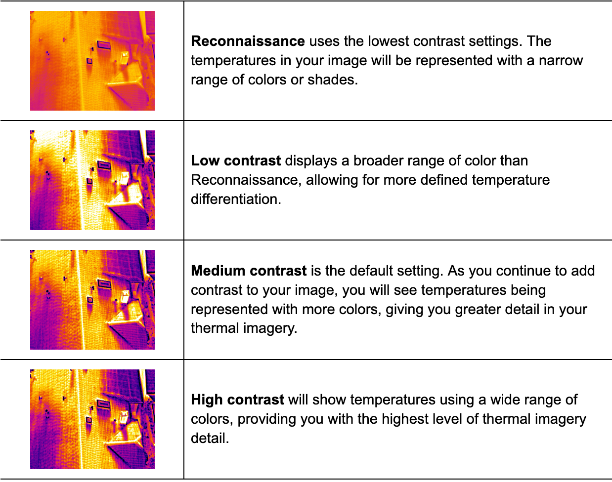
The ability to toggle between additional options in colors and shades can help to detect multiple temperature ranges within an operation more effectively. Whether your organization is assessing a bridge deck for areas of delamination, inspecting transmission assets to identify hotspots before an expensive outage occurs, or looking for humans during a search and rescue mission, you can adjust thermal contrast on a scene-by-scene basis to get the data you need to inform accurate decisions.
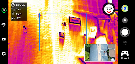
Region of Interest (ROI)
In addition to new thermal contrast settings, we’ve also added the ability to select a Region of Interest (ROI) and apply AGC to that specific area within an image. This feature is vital when a hotspot or temperature irregularity is detected, and you need to quickly diagnose a thermal anomaly while disregarding sections of the reading that are not the primary focal point. For example, scenes with large amounts of background in the frame that typically show as cooler to the thermal sensor, such as the sky. Doing so can improve the thermal contrast of the component you are most interested in and ultimately make it easier to diagnose thermal irregularities.
Upgraded thermal video feed
We’ve implemented new updates that bring you an improved infrared streaming quality. Previously, a constant bit rate was used regardless of the wireless channel conditions. If conditions are optimal, your skydio drone will now use an adaptive bit rate that adjusts depending on the wireless channel conditions of your range and environment, ensuring the smoothest possible streaming experience.
Thermal imaging applications
Thermal imaging detects infrared radiation to see objects from a unique perspective by distinguishing the relative temperature to help you see warmer objects against cooler backdrops. Improvements to sensors, thermal data quality, and the ability to visualize thermal data to extract information that may not be readily visible to the naked eye have resulted in the adoption of the technology from numerous stakeholders across various use cases. Today, drones and thermal sensors are combined to open up new possibilities for safer and even more efficient thermal data collection.
How thermal drones are used for inspections
From inspecting substations and voltage switches for signs of resistance to assessing bridges and buildings for signs of delamination, there are many non-invasive drone thermal imaging applications for monitoring and diagnosing the condition of electrical components and building materials.
Energy & utility inspections
In energy and utility inspections, drones with thermal cameras are being increasingly used to improve safety, scale operations, and pinpoint temperature differences that often indicate faulty or failing equipment year over year. Electrical grid and equipment maintenance teams use drones and thermal sensors to assess the temperature of electric components, which if damaged, begin to emit heat and become visible with a thermal imaging camera. The resulting rise in temperature can lead to expensive, unplanned outages and injuries. However, many manual drones today struggle to operate in energized, obstacle-dense environments. Skydio’s unique ability to operate with no electric or magnetic field impact on the aircraft's flight behavior, collision avoidance systems or command and control systems make them the optimal tool for inspecting energized assets. Especially in energized environments, a non-contact method of inspecting the asset is essential, as physical contact with a failing component can lead to severe injury or death.
Bridge & transportation inspections
With drones and thermal sensors, bridge inspection teams streamline operations, completing safer inspections more efficiently without the need for expensive snooper trucks and time-consuming, potentially hazardous lane closures. Traditional methods of bridge inspections like visual assessments and chain dragging to identify areas of delamination continue to be employed today but rely on manual, often subjective practices that pose a significant risk if defects go undetected. Many agencies are beginning to employ advanced, non-destructive technologies in the form of infrared thermography to quickly identify the full extent of defects in bridge decks like cracks and delamination that may not be readily apparent to an on-site inspector.
Commercial roof inspections
Commercial roof inspections are notoriously hazardous. Climbs and the potential for falls pose a significant risk to inspectors. Drones equipped with thermal cameras are increasingly employed as supplemental inspection tools for preliminary and secondary roof verification. Rather than sending an employee on a climb without a complete understanding of the roof's health, inspection teams are leveraging thermal data captured via drone for initial inspections that are used to inform decisions and identify potentially hazardous areas of a roof before anyone is granted roof access.
Additionally, thermal drones are being used to verify initial findings and determine the true extent of the possible damage. Some of the most common causes of roof damage are breaks or leaks in the roof seal that lead to moisture entrapment. Signs of water ponding and moisture entrapment are often visible on a roof surface in the form of stains, but the severity of water damage can extend far beyond the region with visible stains. Thermal sensors enable inspection teams to verify areas of water ponding from an initial inspection and understand the impacted roof area before taking corrective action.
How Thermal Drones are Used for Public Safety
Search & Rescue Operations
Capable of traversing rugged terrain and saving significant amounts of time in often time-sensitive situations, thermal drones provide unique capabilities for emergency response teams. Rescue operators are finding success with the ability to scan large areas through high-fidelity aerial imagery and thermal data, expediting the process of locating a missing person or animal. In many cases, SAR operations are conducted in obstacle-dense environments like heavily wooded areas. With Skydio’s world-leading obstacle avoidance, operators can focus on the task at hand, locate the missing individual, and fly confidently in tight spaces.
Security & Law Enforcement Operations
From suspect searches and tactical support to SAR operations and evidence retrieval, there are many applications for thermal drones in law enforcement. Drones provide an aerial perspective that enables teams to maintain officer safety. At the same time, thermal sensors help detect individuals and evidence at night in poor visibility conditions without the need for additional lighting. Thermal imagery is increasingly instrumental during night operations, enabling law enforcement agencies to continue operations via the ability to visualize temperature differences that are typically more noticeable as the sun sets and temperatures cool. By equipping drones for law enforcement with thermal cameras, law enforcement agencies are enabled with a powerful tool to locate suspects efficiently, clear potential threats in close-quarter environments, and recover discarded evidence.
Skydio X2E Color/Thermal
Skydio X2E Color/Thermal is an ideal UAS solution for inspections, aerial situational awareness, and search & rescue missions. X2E is powered by Skydio Autonomy Enterprise, an AI-driven autonomous flight engine that enables unparalleled 360° obstacle avoidance, autonomous tracking, GPS-denied navigation, and complete workflow automation. X2E is designed with a ruggedized, foldable airframe, GPS-based night flight, strobing lights in visible and IR wavelength, and a dual-sensor payload with a 12MP color camera and FLIR® 320x256 thermal sensor.
Built for enterprises and first responders, Skydio X2E is designed and assembled in the USA, and is compliant with the National Defense Authorization Act (NDAA).


