Preserving Nepal’s Changu Narayan Temple with Skydio 3D Scan
 Mira Marquez
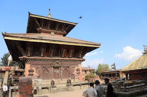
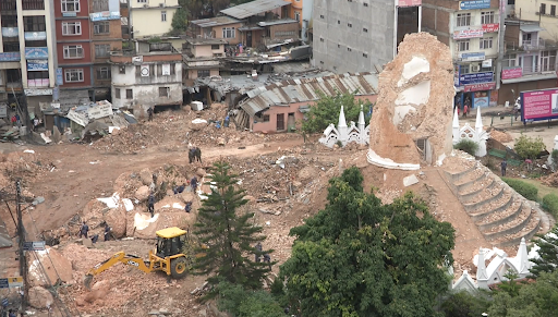
Culturally historic sites across the globe are a gateway to our past, binding us to our ancestors' way of life. Every site is vulnerable to destruction and can disappear in an instant. Whether this is from man-made events like the war in Ukraine where UNESCO has sited over 150 sites damaged or destroyed, or natural disasters such as the severe 2015 earthquake in Nepal which destroyed 80% of the historic structures and temples in both Bhaktapur and Kathmandu Durbar Squares. There is an alarming need to accelerate conservation efforts through the digital documentation of historic sites in order to preserve them for the future and ensure documentation is sufficient should sites need to be rebuilt.
Deep in the Himalayas, Nepal is home to ten UNESCO World Heritage Sites, seven of which are located in the Kathmandu Valley. Kathmandu Valley is an ancient cultural and administrative hub that is home to thousands of temples, monuments, and palaces of significant cultural and historical importance.
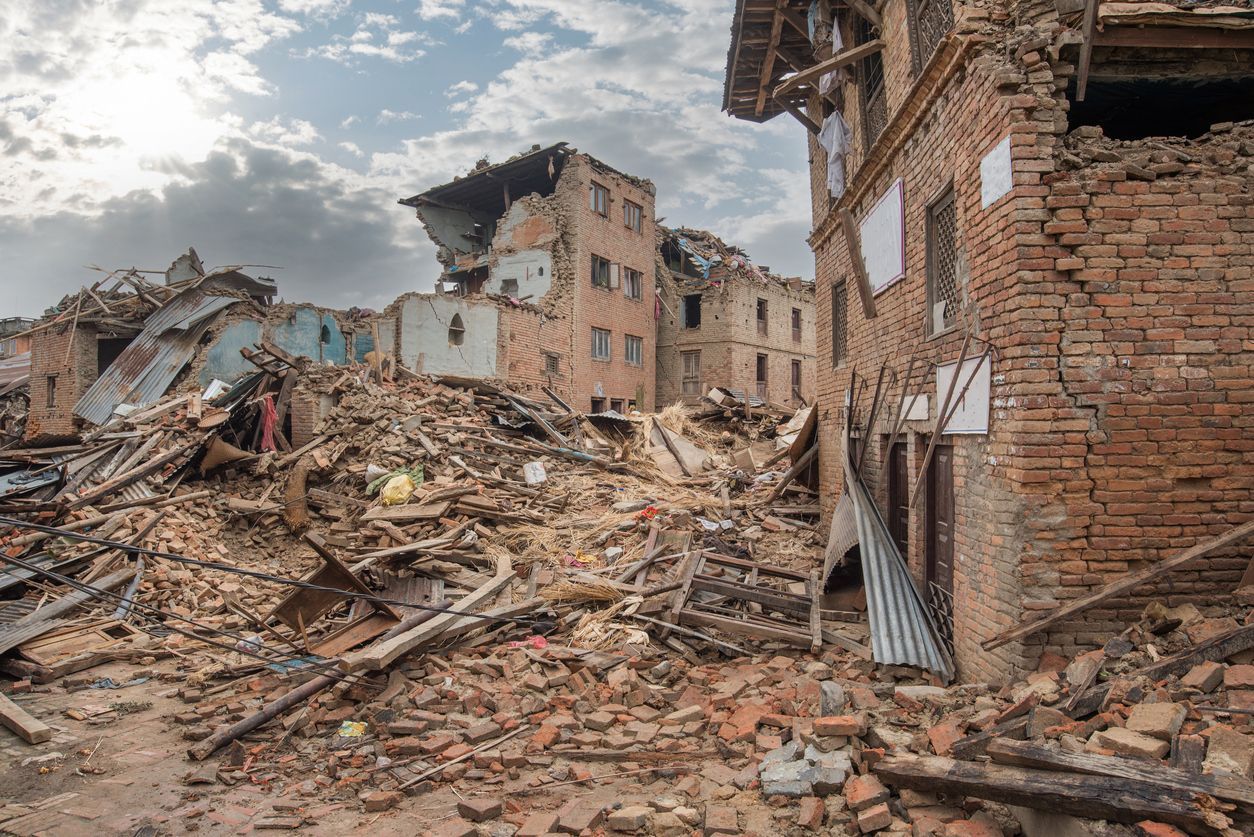
In April 2015, Nepal suffered a devastating 7.8 earthquake, resulting in massive loss of life with nearly 9,000 deaths and thousands more injured. Over 6,000 structures were damaged in Kathmandu. It took a substantial period of time for relevant agencies to even start the reconstruction of the heritage sites, as no accurate and detailed scans existed nor were there enough resources to complete all of them within a short timeframe.
Partnering with Nepal Flying Labs
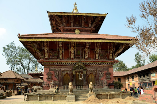
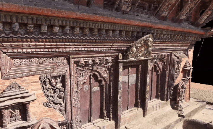
In 2021, Skydio partnered with WeRobotics to host a microgrant scholarship to Flying Labs across the globe in order to provide resources and support for projects in which Skydio Autonomy and products could provide an immensely positive impact. Each Flying Labs emerges from locally-led efforts in response to pressing challenges in a community. Of the proposals submitted, Nepal Flying Labs was selected as a recipient for their project to create a digital twin by mapping Changu Narayan Temple, the oldest temple in Kathmandu Valley dating back to the 5th Century. During the 2015 earthquake, the two-tier pagoda temples of Changu Narayan were seriously damaged, highlighting the growing need for digital preservation.
Nepal Flying Labs pilots initiatives with international humanitarian organizations and the local governments to support emergency response and reconstruction through the use of emerging technologies. Their early initiatives initially focused heavily on damage assessment and situational analysis before taking a more proactive role in preservation as technologies improved and new solutions emerged. Based on the experience of Nepal Flying Labs working with multiple governments at both local and central level during other mapping projects, the main challenge identified during the reconstruction efforts of heritage sites after the 2015 earthquake was a way to preserve the physical presence, integrity and architectural aesthetics of the structures, some of which date back several hundreds of years.
In this regard, Nepal Flying Labs stated recent studies show that, with the frequent earthquakes and the subsequent aftershocks, most of the historical buildings and cultural sites in Nepal, along with the ones in Changu Narayan Municipality, have taken heavy amounts of damage, making the structures fragile and vulnerable over time.
Mapping Heritage Sites with Skydio 3D Scan
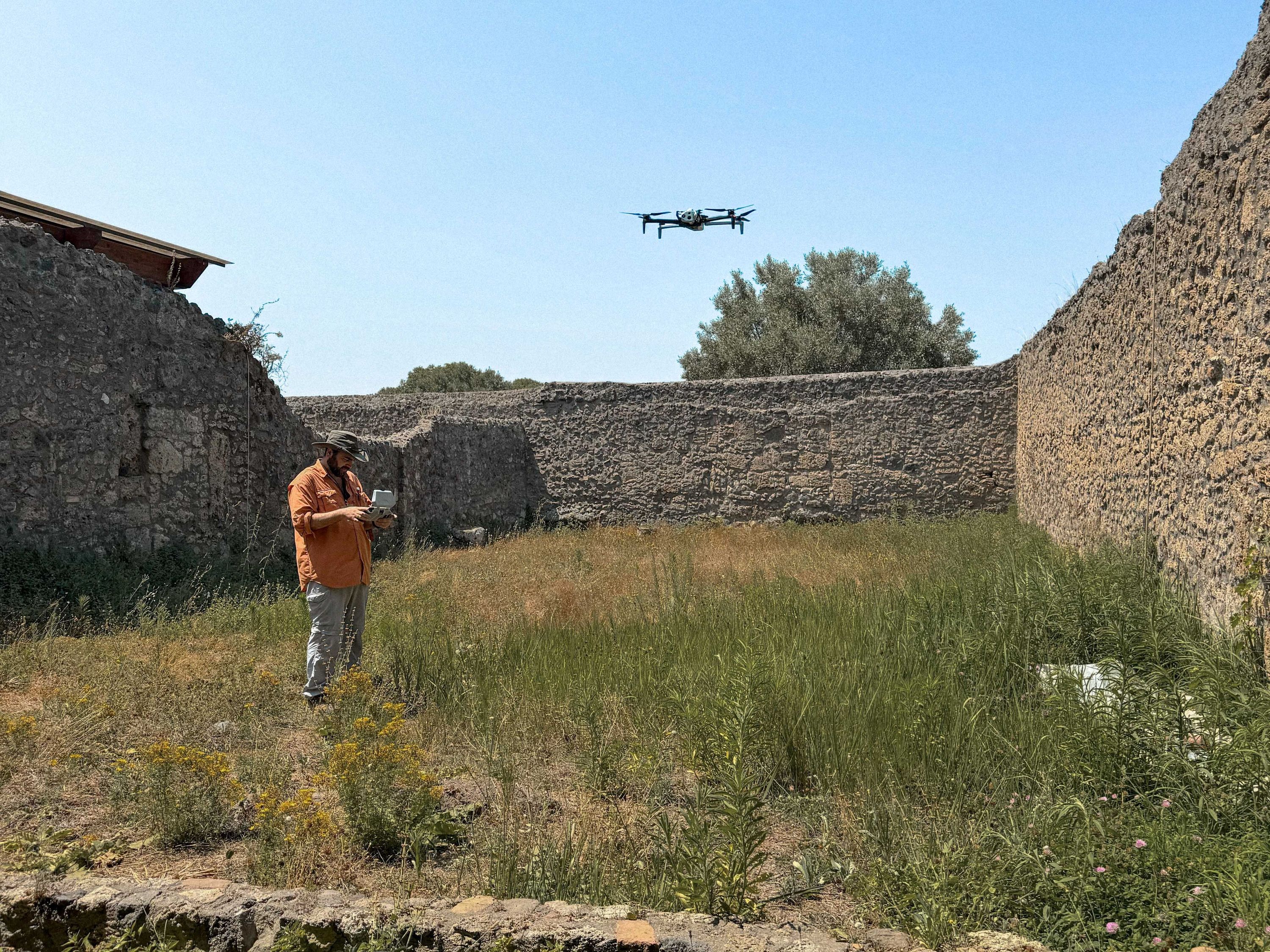
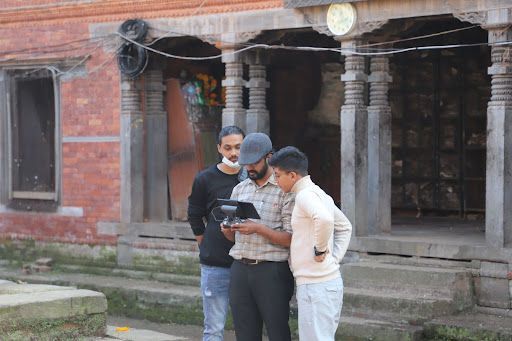
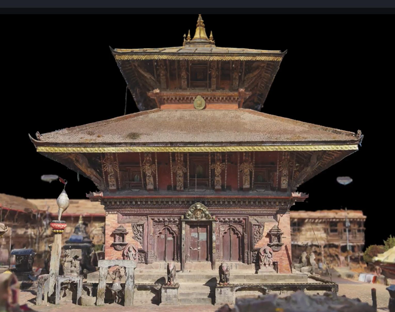
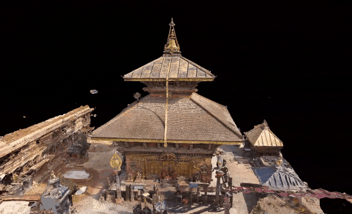
By leveraging Skydio 3D Scan to create a digital twin of Changu Narayan Temple, any agency such as Department of Archaeology, UNESCO, Changu Narayan Municipality, representatives from world heritage sites, and any other concerned stakeholder and individuals are able to use the high resolution images, video clips and 3D model for aiding in reconstruction and documenting structural changes over time. Throughout the process, Nepal Flying Labs worked cooperatively with multiple agencies, such as Department of Archaeology, Changu Narayan Temple Preservation Committee, District Administrative Office, and local police to assist in the logistics of permits, drone operation permissions, and closing off the site for a short period of time to conduct flights. Nepal Flying Labs was able to safely fly around the temple and close enough to capture intricate details thanks to Skydio Autonomy and reduced obstacle avoidance. After the flights, the data was processed in Bentley’s Context Capture to create the Changu Narayan Temple 3D Model. Nepal Flying labs and the local municipality now have a foundation to compare future scans against to assess deterioration, damages, and weather affecting the structure over time; a digital interactive health status.
The process of mapping of Changu Narayan Temple provides insight into the complex nature of how to approach conservation of Heritage sites using drones. Nepal Flying Labs approached the project with extreme care as the sentiments of the local communities need to be well understood and critically evaluated. Historically, mapping heritage sites, especially with drones, is banned unless there is an extremely critical need for the work. They formed a consortium of relevant government authorities, and local stakeholders to obtain consent for data acquisition as it was crucial for heritage mapping and maintaining the integrity of heritage sites. We would like to thank the officials from the Changu Narayan Municipality and the Department of Archaeology for their support in securing permissions for drone flights in the temple’s No Fly Zone airspace; this aspect of the work was handled with the utmost care and cooperation. This partnership highlights how vital it is to utilize locally led, on the ground, organizations as they live in the communities they operate in and have a deeper understanding of the local culture and practices in order to maintain the integrity of the site’s value to the community.
Next steps in heritage preservation
After the success of documenting this first heritage site, Nepal Flying Labs is continuing to work with the Government of Nepal on efforts to map and create digital twins of other World Heritage Sites in Nepal. They are organizing a technical workshop with the Department of Archaeology in the near future with experts in historic preservation to gather additional feedback on improvements for continuing heritage documentation. Skydio’s expert obstacle avoidance makes it an ideal platform for mapping historic sites closely without fear of crashing or damaging the site. At Skydio, we look forward to supporting Nepal Flying Labs in their efforts to preserve these historic sites for future generations.
There will never be a perfect social or economical time to engage in cultural and historical preservation initiatives. It’s vital to start now, because mother nature and war don’t pause for preservation. Locally led efforts lead to a significantly higher project sustainability due to locals understanding and living in the communities they are trying to help. Heritage preservation projects take time; it means working with local authorities, government officials, working through elections, and local aviation authorities which can range anywhere from a couple months to a couple years. All the more reason on the ground locally led efforts are needed. Skydio understands it may take years for our technology to reach various communities and corners of the world. Which is why, if there is a deep need in your community for support much like the Nepal Flying Labs, please reach out to Skydio For All at skydioforall@skydio.com.