

I am excited to expand on how 3D scan models can go beyond inspecting a structure for enterprises - as we showed in previous blogs with lunar lander and the Sepulveda Dam, and dive into how it can be helpful for public safety agencies. So today we’re going to go over a car accident scene reconstruction, documented by Skydio 3D Scan in less than 5 minutes!
The model (click here to see it in 3D on the Skydio Sketchfab!) is of a mock car accident staged by our state and local government account manager John Santry. Crashes, especially those with fatalities, must be fully documented with photographs and precise measurements to enable further investigations after the debris is cleared from a busy roadway. Here are three reasons Skydio 3D Scan will make a huge difference:
- Precision: Even the world’s best drone pilot would be hard-pressed to get the kind of data you can get with 3D Scan. Thanks to cutting-edge AI, 3D Scan makes sure you get up-close imagery with full coverage of the structure at a consistent resolution, making it possible to determine where people and objects were in physical space. Crash analysts can then determine how subjects’ positions, directions, and speeds changed as the incident unfolded.
- Speed: Traditional car accident investigations can cause hours of disruptive lane closures as authorities document evidence. With quick setup, Skydio’s drones equipped with 3D Scan can fly autonomously without the fear of crashing, substituting worker hours and timely inspections for quick image and data collection so accidents can be cleared faster.
With Skydio 3D Scan, I was able to quickly set up a flight mission from a safe vantage point. In this case, I was in a training environment approximately 50 feet away from the vehicle in a shaded location hiding from the summer heat. Had I been on a live scene on a busy roadway, I very easily could have been doing this from a protected location out of harm’s way and away from moving traffic. Compound that with the ability to scan a vehicle in minutes as opposed to hours with traditional ground scanners, and you can easily see how this technology not only improves data quality but also benefits officer safety.
John Santry
Enterprise Account Manager
- Reliable: With 3D Scan’s Edge Model Viewer, a solution that allows the operator to view a simplified 3D model of a scanned scene directly after flight by connecting the drone to a laptop, the operator can validate full coverage of the field scene, ensuring he/she has what is needed before clearing the debris from roadways. So whether a set of nicely-indexed photos or a full-blown 3D model is needed, a pilot can make sure he/she has all the right data by the time it lands.
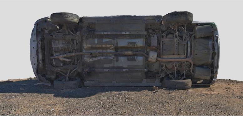
This is a screenshot from the 3D model showing the details underneath the car wreck. The drone flies very close to the ground, getting clear details from the floor and car.
Traditional methods for gathering evidence, like taking photographs and measurements or using a manual drone that cannot fly near obstacles or metal, compromise data accuracy.
At Demo Day we were able to see first-hand what Skydio drones can do. My team was blown away by the cutting edge technology, and I don’t think there’s any other like it. This is a game changer for law enforcement and other sectors.
James Munro
Jim Munro, Police Lieutenant - Clovis Police Department
3D Scan is first-of-its-kind adaptive scanning software built on top of Skydio Autonomy, and was recently named a finalist in the innovation category for the 2021 AUVSI XCellence Awards. 3D Scan automates data capture of any scene with comprehensive coverage and ultra-high resolution, so that crews can perform higher quality investigation in less time and with minimal pilot training.
How Skydio wins
All Skydio drones use six 4K navigation cameras to build a map of their surroundings, deep learning algorithms to understand what they're seeing, and advanced AI to predict into the future and make intelligent decisions. 3D Scan is a software add-on that augments the core autonomous flight engine with a broad set of capabilities for scanning complex scenes, one of them being the new Adapting Mapping algorithms.
The Adaptive Mapping algorithms of 3D Scan allow Skydio drones to iteratively design a structure-specific 3D scanning path, and follow it with robotic precision and full obstacle avoidance engaged. This allows the drone to capture imagery up close, from multiple angles, and at a pre-specified resolution, giving the accident investigators a holistic view of what happened. This ability to create a 3D digital twin provides the necessary context of the accident scene that is hard or impossible to capture with a 2D flight pattern map or still photography. With most 2D capture solutions, the operator generates a top down view of the scene, but fundamentally limits the amount of information collected by the reconstructionist. Being able to understand what is happening on the sides of the crash scene and to fully see the depth of the scene is where the real value of having a 3D model comes from. Being able to accomplish all this with minimal operator preparation and in record time to minimize the societal impact is where the unique value of Skydio 3D Scan is realized.
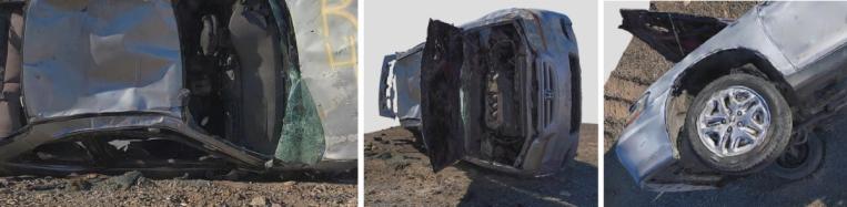
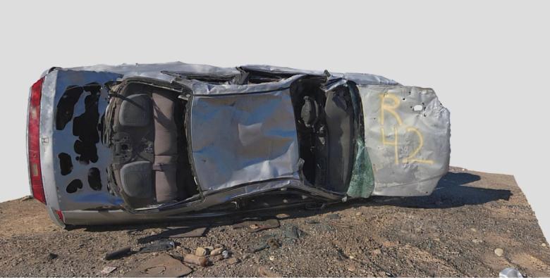
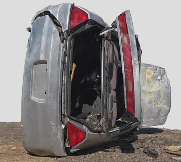
These screenshots from the 3D Model shows the benefits of being able to fly up close - capturing incredible detail from all angles of the structure.
First responders need to focus on many things at once, including saving lives, clearing the site as fast as possible to minimize disruption, and documenting the scene of the incident. Skydio 3D Scan makes the scene documentation process easy with adaptive mapping algorithms that pilot the drone to make a structure-specific 3D scanning path, and follow it with full obstacle avoidance engaged. This unique hardware and software combination gives first responders an easy to use tool that really makes a difference in the field.
Want to see more?
Check out the mock helicopter crash site and a car crash scene for more examples on how 3D Scan is revolutionizing evidence documentation.
Additional capture details are below. To learn how you can apply this incredible new technology to your inspection operations, please do not hesitate to contact us.
ADDITIONAL CAPTURE DETAILS
This model features 210 photos stitched together in Bentley ContextCapture.
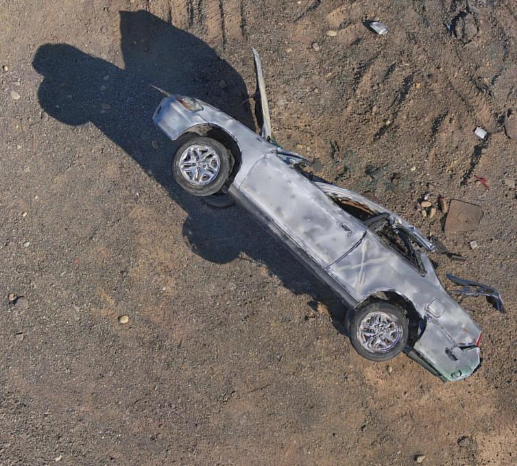
As you will notice if you follow the link to our Sketchfab account, the model contains incredible detail of all sides and angles of the car, which would be impossible to document with a manual drone’s simplistic top-down flight.
Capture
- Platform: Skydio 2
- Date: June 4, 2021
- Distance: 7 feet
- Ground Sampling Distance (GSD): 0.8 mm
- Overlap / Sidelap: 80 / 70%
- Photos: 210
- Flight Time: 3 min (< 1 battery)
Processing Package: Bentley ContextCapture
Pilot Spotlight: John Santry

John served 10 years on active duty in the U.S. Navy as a C-2 Greyhound Flight Engineer, and later as a Tactical Surveillance and Reconnaissance specialist for Naval Special Warfare, supporting SEAL Teams 5 and 7 as a UAS Pilot in Iraq.
After leaving active duty in 2012, John went on to work for General Atomics Reconnaissance Systems Group and Boeing’s Insitu, Inc. as a UAS Mission Coordinator and ScanEagle Pilot for USSOCOM in Afghanistan.
John’s experience in commercial UAS dates back to 2014 where he launched and ran a Section 333 certified drone service provider that offered early photogrammetry, inspection, and cinematography services to the San Diego and Los Angeles markets. For the last several years, John has been working in the drone-focused tech industry as the former Enterprise Sales Director for Kittyhawk.io (now Aloft.ai), and more recently as Skydio’s Senior Account Executive for the Western half of the United States. Originally from Richmond, VA, John now lives in Phoenix, AZ, with his fiance Tiffany and two dogs Penny and Coco. He also holds an MBA from Embry-Riddle and is a licensed Part 107 operator.

